Slightly better night’s sleep with only 6 trains coming
through!
We took advantage of the discounted buffet breakfast at the adjoining
motel and heard about the bear that had been roaming outside the bedroom
windows last night. We then set off to
drive around the southern edge of Glacier NP as vehicles over 21 feet long cannot
use the road that goes over the Continental Divide through the middle of the
park.
We stopped in the town of Browning, which is in the middle of
the Blackfeet reservations lands. We
visited the Museum of the Plains Indian which, although small, was very
interesting. They had some excellent displays
of clothing and other Native Americans artefacts persevered from the 1800s.
 Most national parks are surrounded by national forest or
wilderness area, but in this case the east side of Glacier NP is bordered by
the Lands belonging to the Blackfeet, right up to the Canadian Border. The Blackfeet Land used to include these
mountains east of the Continental Divide (or what they called the Backbone of
the World) and the Blackfeet still contest this point.
Most national parks are surrounded by national forest or
wilderness area, but in this case the east side of Glacier NP is bordered by
the Lands belonging to the Blackfeet, right up to the Canadian Border. The Blackfeet Land used to include these
mountains east of the Continental Divide (or what they called the Backbone of
the World) and the Blackfeet still contest this point.
Glacier NP is right on the border with Canada and there is a
similar park in Alberta called Waterton Park.
Glacier and Waterton were joined in 1932 to become the world’s first
International Peace Park and the two countries work closely together on
managing the parks.
 We carried on up the east side of the park to the St Mary NP
campground. Whilst taking a drive around
the park to get familiar with the area we spotted a bear crossing the
road. Bears have been seen in the campground
and the Rangers advised on what to do if we encountered one.
We carried on up the east side of the park to the St Mary NP
campground. Whilst taking a drive around
the park to get familiar with the area we spotted a bear crossing the
road. Bears have been seen in the campground
and the Rangers advised on what to do if we encountered one.
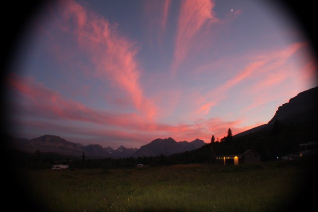
22nd August St Mary Lake
 |
| View from campground |
We carried on up the east side of the park to the St Mary NP
campground. Whilst taking a drive around
the park to get familiar with the area we spotted a bear crossing the
road. Bears have been seen in the campground
and the Rangers advised on what to do if we encountered one.22nd August St Mary Lake
 |
| St Mary Lake |
did not want to be caught for our supper today.
Alison went to the park evening programme which turned out
to be a singer, and his daughter, from the local Blackfeet population. He sang his own songs about traditional
subjects but to folk/country style music.
His daughter told some traditional stories and did Blackfeet sign language
to one of the songs.
23rd August Avalanche Lake
 |
| Continental Divide |
 |
| Avalanche Lake |
 |
| St Mary's Falls |
On the return journey we spent a little longer at Logan’s Pass enjoying the views. There were several ground squirrels scampering around and calling to each other. Alison spotted two climbers at the top of Reynolds Mtn at 9125ft with the binoculars. The highest mountain in the park is Mt Cleveland at 10466ft; much smaller than those in the Rocky Mountain NP.
In the evening we then met up with Larry and Penny again. Their friends Dan and Sally joined us for a
meal and then everyone came back to the RV for a couple of hours when Paul got
out the bottle of Jameson’s.
24th August
Baring, St Mary and Virginia Falls
 |
| Virginia Falls |
 |
| Lower Virginia Falls |
We then followed the Virginia River passing a number of other waterfalls until we eventually arrived at Virginia Falls and watched water cascading from high above as we ate lunch in the sun.
Alison cooled her feet in the waters but within a few
seconds they were going numb. It was
also quite slippery and in fact we saw someone slip up. Apparently the most fatalities in the park
occur from drowning in the icy waters (not bear attacks). There had been a bear sighting at our
campground again – but we missed it.
25th August Two Medicine
 |
| Running Eagle Falls |
The Mountains were gradually disappearing from view. By the time we got home they were a shadowy
out-line. We learnt that it was smoke
being blown from the south and west from the forest fires in California and
Idaho.
26th August Many Glacier
 |
| Many Glacier Hotel |

We decided to take the boat tour which crossed two
lakes. First was Swift Current Lake,
followed by a ¼mile walk to the next boat crossing over to the other side of Lake
Josephine. From there we hiked up to
Grinnell Lake and sat by the acqua-marine blue waters looking up at Grinnell
Glacier. The water is pouring from the glaciers; by 2030 these glaciers will have melted. In 1850 there were 150 documented glaciers,
but now there are only 25. The
definition of a glacier is: an area of 25 acres or more, 100 thick deep and moving (usually from its own weight and in the direction of gravity); otherwise it is just a bit of old ice I guess.
 |
| Falls from Grinnell Glacier |
definition of a glacier is: an area of 25 acres or more, 100 thick deep and moving (usually from its own weight and in the direction of gravity); otherwise it is just a bit of old ice I guess.

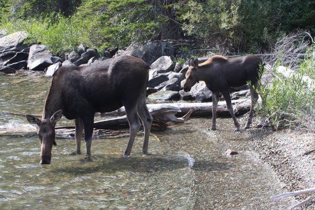 The return journey is the reverse of the outgoing trip. During the ¼ mile walk between boats we were
honoured with the presence of a mother Moose and baby. This
The return journey is the reverse of the outgoing trip. During the ¼ mile walk between boats we were
honoured with the presence of a mother Moose and baby. This
made our day and made up for no bear sightings.
The return journey is the reverse of the outgoing trip. During the ¼ mile walk between boats we were
honoured with the presence of a mother Moose and baby. Thismade our day and made up for no bear sightings.
27th August Hidden Lake and Garden Wall
 At Logan’s Pass on top of the Continental Divide we couldn’t
find any parking so had to drive down to one of the bus stops and catch the
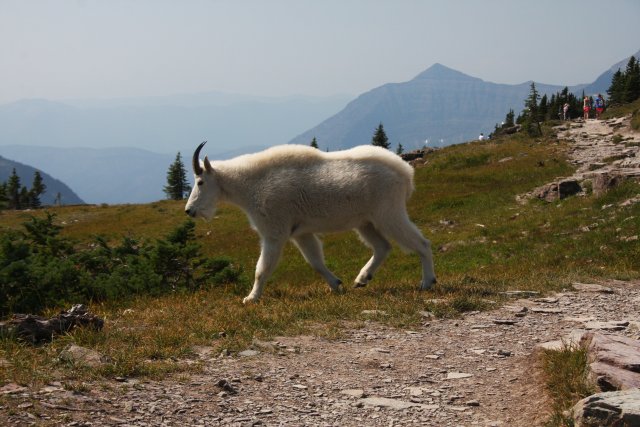
shuttle bus back up. From there we hiked
to Hidden Lake and were treated to some close encounters with Mountain Goats.
At Logan’s Pass on top of the Continental Divide we couldn’t
find any parking so had to drive down to one of the bus stops and catch the
shuttle bus back up. From there we hiked
to Hidden Lake and were treated to some close encounters with Mountain Goats.  There were a number of Rangers
who were there on a Goat collaring exercise as part of their monitoring
processes. We watched as they found a
suitable male goat, which promptly made a hasty exit down the mountain. So unfortunately we didn’t witness the full
process but could see it was going to involve a tranquiliser gun.
There were a number of Rangers
who were there on a Goat collaring exercise as part of their monitoring
processes. We watched as they found a
suitable male goat, which promptly made a hasty exit down the mountain. So unfortunately we didn’t witness the full
process but could see it was going to involve a tranquiliser gun. |
| Garden Wall Drop-off |
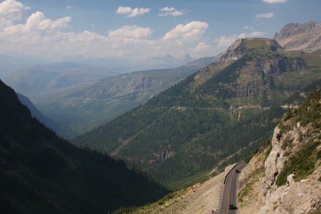 We then had time between shuttle buses to hike part of the
Highline Trail. The trail follows the ridge of Mountains on the Continental Divide and is called the Garden Wall.
The first part was along the cliff edge with a sheer drop off on one
side. We were glad there was a chain
rope to hold onto for that part. The
Garden Wall section was much easier and was covered with a lot of vegetation. We felt really high up here looking down onto
the east side of the Going-to the-Sun road.
We then had time between shuttle buses to hike part of the
Highline Trail. The trail follows the ridge of Mountains on the Continental Divide and is called the Garden Wall.
The first part was along the cliff edge with a sheer drop off on one
side. We were glad there was a chain
rope to hold onto for that part. The
Garden Wall section was much easier and was covered with a lot of vegetation. We felt really high up here looking down onto
the east side of the Going-to the-Sun road.
In this region the Continental Divide is actually a Triple
Divide. Not only do waters travel to the
Pacific Ocean to the east and the Gulf of Mexico and Atlantic ocean to the west
but they also flow to the Hudson Bay to the north.
No comments:
Post a Comment